


Contact Info
Bedford, IN 47241
- Phone:
- 812-275-5987
Basics
- Size:
- 140 acres / .2 sq. miles
Description
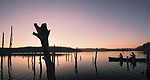
Springs Valley Recreation area in Orange County is located west of State Highway 37 south of Paoli.
The new Springs Valley Trail, which circles the lake was opened in November 2002.
The 140-acre lake surrounded by scenic hardwood forests features primitive camping with vault toilets only. No drinking water is available. A boat ramp and picnic facilities are also available. No fees are charged. Visitors to this area should be aware of a vandalism problem in this area and people are asked to report any suspicious activity or damage.
Details
Size:
Additional Details:
Do not bring firewood into Forest picnic areas or campgrounds! Firewood could transport emerald ash borer. Only local firewood should be used.
Most of the bluegill are 7-to 9- inches long, and redear up to 11inches are common. The big blue gill and redear are found in about 12 feet of water in the middle of the bays with creek channels, according to biologist.
Biologists recommended not fishing in deeper than 15 feet because dissolved oxygen level below that depth won''t allow fish to survive at those levels during summer months.
Channel catfish are found in abundance throughout the entire lake. Most of the fish are between 14- and 18- inches long. Biologists caught four channels longer than 26 inches. The largest catfish was nearly 29 inches.
Amenities
Map + Directions
Basic Directions
From Hwy 37 - From Hwy 37 south of Paoli turn right on Unionville Road, proceed for 1 mile, turn right at brown FS sign onto County Road 150 S. and proceed 1.1 miles to stop sign and turn left onto County Road 225 W, proceed 2.1 miles to brown FS sign and bear right on 325 S for 1.9 miles to stop sign, turn left on 500 W and go .8 miles to brown FS sign and turn Left on County Road 550 W. and follow this road back to Springs Valley Lake.
From Hwy 145 - Take Hwy 145 South out of French Lick 6.4 miles and turn left at brown FS sign on Baseline Liberty Road and proceed 1.3 miles, turn left on County Road 650 W at brown FS sign and proceed 1.8 miles to “Y” in road, bear right (stay on 650 W) and proceed 0.8 miles to stop sign, turn right onto 600 W and proceed 0.5 miles to 550 W. Turn right at brown FS sign and follow back to Springs Valley Lake.

